
The Danube Delta: map, what it is, the villages and what to see

The Danube Delta is where the Danube, after 2,860 km, splits into three branches, the Chilia, the Sulina and the Sfântu Gheorghe, and flows into the Black Sea, in eastern Romania, in Tulcea County. The Danube Delta Biosphere Reserve covers about 580,000 ha, has been on the UNESCO World Heritage List and the Ramsar list since 1991, and you enter it from Tulcea, almost only by water. In summer 2026 the water level dropped so far that boats struggled to reach some channels; the situation at the end of October is set out below.
This guide shows the delta on the map, branch by branch, with the villages and sights on each, then what you see at every place that has a page on the site: Mila 23, the Letea and Caraorman forests, Gura Portiței, Lake Razim, the beaches at Sulina and Sfântu Gheorghe, the fortresses around Razim and the aquarium in Tulcea. At the end come the superlatives, Romania's other "deltas" and the places people confuse with the delta.
In short
- The Danube Delta is where the Danube splits into the Chilia, Sulina and Sfântu Gheorghe branches and flows into the Black Sea, in eastern Romania.
- The Danube Delta Biosphere Reserve covers about 580,000 ha, roughly 5,800 km², of which 87.73% is in Tulcea County, 12.23% in Constanța and 0.14% in Galați (ARBDD).
- The delta has been a biosphere reserve since 1990, a wetland of international importance (Ramsar) since September 1991 and on the UNESCO World Heritage List since December 1991.
- The reserve has 365 recorded bird species, 135 fish species and 51 mammals, and about 70% of the delta's vegetation is dominated by reed (ARBDD).
- Sulina, Sfântu Gheorghe, Mila 23, Crișan and Caraorman have no road: you reach them only by water, on the Navrom Delta ships or by boat, from Tulcea.
- In summer 2026 the water fell, ARBDD banned gillnets from 7 July, and on 30 October 2026 the Danube stood at 13 cm on the Tulcea gauge (AFDJ).
What the Danube Delta is: facts, area and where it is
The Danube Delta is Romania's youngest region: it formed over the last ten thousand years from the river's sediment and still grows towards the sea by a few metres a year. At the end of its 2,860 km, the Danube divides into three branches, and between them lies a maze of channels, creeks, lakes and plaur, floating islands of reed. On the sandy ridges (grinduri), strips of land higher than the water, grow the Letea and Caraorman forests and stand the villages of the same names.
The Danube Delta Biosphere Reserve takes in the delta itself and the surrounding units, among them the Razim–Sinoe lake complex in the south, and covers about 580,000 ha. Most of it is in Tulcea County, the rest in Constanța, on the coast at Vadu and Corbu and at Histria, plus a small strip in Galați. Only a few thousand people live in the delta, in Lipovan, Ukrainian and Romanian fishing villages and in the town of Sulina.
The table below gathers the basic figures, according to the Danube Delta Biosphere Reserve Authority (ARBDD). Ship timetables, prices and photos are on the page of the Danube Delta.
| What | Danube Delta |
|---|---|
| Where it is | eastern Romania, in northern Dobruja, between Tulcea and the Black Sea |
| Counties | Tulcea (87.73%), Constanța (12.23%), Galați (0.14%) |
| Area of the reserve | about 580,000 ha (roughly 5,800 km²) |
| Of which on the UNESCO World Heritage List | 340,000 ha |
| Branches | Chilia (north), Sulina (centre), Sfântu Gheorghe (south) |
| Biosphere reserve | since 1990 |
| Ramsar wetland / UNESCO | since September / December 1991 |
| Strictly protected zones | 20, over 50,904 ha (8.7% of the reserve) |
| Species | 365 birds, 135 fish, 51 mammals; 4,286 animal species, 2,994 plant taxa |
| Gateway | Tulcea; beyond it, almost only by water |
Figures from ddbra.ro (about the reserve, international recognition, functional zoning, flora and fauna), checked on 30 October 2026. 5,800 km² is the conversion of the 580,000 ha.
Top 20The Danube Delta on the map: branches, villages and sights
On the map of Romania, the Danube Delta is in the country's eastern corner, on the Black Sea, next to Ukraine, with which it shares a transboundary biosphere reserve; the beach at Sulina is the easternmost inhabited place in Romania, where the sun rises first. Tulcea, at the entrance to the delta, is the town from which ships leave along all three branches.
The easiest way to read the delta is branch by branch. The Chilia branch, in the north, is the route of the Navrom ship to Periprava; the Sulina branch, in the middle, is the main line, Tulcea – Sulina, with Crișan halfway and Mila 23 on the Old Danube; the Sfântu Gheorghe branch, in the south, runs through Mahmudia to the village at its mouth. Below the delta, linked to the Sfântu Gheorghe branch by the Dranov and Dunavăț channels, lies the Razim–Sinoe lake complex, with Jurilovca, Gura Portiței and the ancient fortresses.
All the sights in the table are on the site's map, filtered on the Deltas category or on the map of Tulcea County; they are listed on the Deltas page, and the rest of the county is on the Tulcea County page.
| Area | Villages (Navrom stops and villages on the ridges) | Sights on the site | How you get there |
|---|---|---|---|
| Chilia branch (north) | Ceatalchioi, Plaur, Pardina, Chilia Veche, Periprava; Letea village, on the ridge between the Chilia and the Sulina | Letea Forest | the Tulcea – Periprava ship; Chilia Veche can also be reached by road |
| Sulina branch (centre) | Partizani, Maliuc, Gorgova, Crișan, Sulina; Mila 23 on the Old Danube, Caraorman on the channel from Crișan | Mila 23, Caraorman Forest, Sulina Beach, Old Lighthouse of Sulina | the Tulcea – Sulina ship; the Crișan – Mila 23 and Crișan – Caraorman launches |
| Sfântu Gheorghe branch (south) | Bălteni de Jos, Mahmudia, Sfântu Gheorghe; Murighiol and Uzlina, near the branch | Sfântu Gheorghe Beach, Halmyris Fortress | the Tulcea – Sfântu Gheorghe ship; Murighiol and Mahmudia have a road |
| Razim–Sinoe (south, lakes) | Sarichioi, Enisala, Jurilovca; Istria, on Sinoe | Lake Razim, Gura Portiței, Enisala Fortress, Argamum Citadel, Histria Citadel | by car to the shore; to Gura Portiței by boat from Jurilovca |
| Tulcea (the gateway) | Tulcea | Tulcea Aquarium (the “Danube Delta” Ecotourism Museum Centre) | by car, train or coach |
The stops are those of the Navrom Delta lines (navromdelta.ro, October 2026); the other locations come from the sights' pages.
The 2026 drought: the water in the Danube Delta
Summer 2026 was dry, the water fell across the whole delta and some channels became impassable for boats. On 7 July, ARBDD banned gillnets in the reserve after the Danube had dropped below 50 cm on the gauge; on the main branches, the Old Danube, Musura Bay and the Sfântu Gheorghe Meleaua they stayed allowed only when the level is above 50 cm. In early August, the ARBDD governor said that the low level "creates great difficulties for boats reaching all the areas of interest", and the authority approved the dredging of the Băltenii de Jos channel, on the Sfântu Gheorghe branch, and the Periteașca channel, between Razim–Sinoe and the sea. At the same time it asked tourists and locals not to speed on the channels and lakes.
At the end of October 2026 the water is still low: on 30 October the Danube stood at 13 cm at Tulcea and 58 cm at Sulina, and the five-day forecast gave 15–18 cm at Tulcea (AFDJ, with the INHGA forecast). Navrom Delta was not announcing any cancelled sailings at the time. For a trip on the small channels, ask beforehand at the ARBDD information centre or the boatman whether the route can still be done.
Mila 23: the fishing village on the Old Danube
Mila 23 is a Lipovan fishing village on the bank of the Old Danube, the river's old bend that leaves the Sulina branch, about 53 km from Tulcea by water. It belongs to the commune of Crișan and has no road at all. The name comes from the measurement in miles of the Sulina branch.
The village is best seen from a boat: reed-roofed houses, pontoons and boats tied up under willows, and in the lanes whitewashed houses with blue window frames and the Old Rite church. Ivan Patzaichin, four-time Olympic canoe champion, came from Mila 23; on the site of his family home a tower museum of wood and reed, 18 m high, with a panoramic terrace, opened in 2024. The Navrom launch from Crișan arrives in the evening and leaves in the morning, so without your own boat a visit means a night in the village. The launch timetable and ways of getting there are in the guide to trips in the delta.

Letea Forest: oaks hung with lianas, dunes and feral horses
Letea Forest grows on the Letea ridge, a sandbank about 14 km long between the Chilia and Sulina branches, north of Letea village. It has been a nature reserve since 1938 and is now a strictly protected zone of about 5,250 ha, of which 2,825 ha are strictly protected.
It is not a solid forest but clumps of oak, ash and poplar, called hasmacuri, growing between sand dunes up to 12 m high. Lianas climb the trunks, above all Periploca graeca, a Mediterranean plant at the northern edge of its range here. Herds of feral horses, descendants of horses set free by the locals, graze the meadows on the fringe.
It can be visited only on three approved routes, only with a licensed guide, starting from Letea village, which you reach by water. There is more about the horses and the forest's birds in the guide to the birds and animals of the delta.

Caraorman Forest: the Kneeling Oak and the highest dunes
Caraorman Forest, "the dark forest" in Turkish, is on the Caraorman ridge, in the centre of the delta, between the Sulina and Sfântu Gheorghe branches. The reserve covers 2,250 ha and is a strictly protected zone. At its southern end stand oaks more than 400 years old, among them the Kneeling Oak, with its branches bent down to the ground, and next to the village are the most developed sand dunes in the delta, up to 9 m high. On the edge of the village you can see the empty blocks of a quartz-sand factory abandoned in the 1990s.
Caraorman village is linked to Crișan by a channel, on which the Navrom launch runs; from the landing stage to the oaks there are about 10 km of soft sand, and since May 2026 ARBDD has banned all vehicles, motorised or not, inside the strictly protected perimeter of the forest (Decision 139/2026). In the forest you may only use the tourist route; ask at the ARBDD centre in Crișan whether it is open.

Gura Portiței: the strip of sand between the sea and Lake Golovița
Gura Portiței is a strip of sand a few dozen metres wide between the Black Sea and Lake Golovița, in the south of the reserve, with no road leading to it: the car stays in Jurilovca, and the boat crossing of the lake takes about 20 minutes. The name comes from the "little gate" (portița) through which Golovița was connected to the sea until the works of the 1970s.
On the strip there is a single resort and the beach around it; beyond the breakwater of concrete tetrapods the shore stays wild. From the same strip you see the sunrise over the sea and the sunset over the lake's reed beds, and boat trips on Sinoe leave from here. Open fires are banned along the whole strip. The beach is compared with Sulina and Sfântu Gheorghe in the guide to the delta's beaches.

Lake Razim: Romania's largest lake, on the edge of the delta
Lake Razim, also called Razelm, is Romania's largest lake: about 415 km², at the centre of the Razim–Sinoie lagoon complex, which spreads over more than 1,000 km² between the delta and the sea. It is shallow, at most 2.8 m deep. In antiquity it was a bay of the Black Sea; works in the 1970s and 1980s closed its mouths to the sea, and today it is a freshwater lake, fed by the Sfântu Gheorghe branch through the Dranov and Dunavăț channels.
In the north is Popina Island, a strictly protected zone that can be seen only from the water; near Jurilovca the rocky islet of Bisericuța rises from the lake. On the western shore, the Lipovan village of Sarichioi has an old fishing harbour, and further south Enisala Fortress and Argamum Citadel stand above the water. For boating, kayaking or fishing you need the ARBDD permit; the fishing rules on Razim are in the guide to fishing in the delta.

Sulina: the beach at the end of the branch and the Old Lighthouse
Sulina is the only town in the delta, a port with no road to the rest of the country, at the end of the branch of the same name. In the second half of the 19th century it was the seat of the European Commission of the Danube, which turned the fishing village into an international port. From that time remain the Old Lighthouse of Sulina, a white tower dated 1870, now a museum of the Institute for Eco-Museum Research in Tulcea, the Commission's palace and the maritime cemetery.
Sulina Beach is 2–3 km east of the town: very fine river sand, a wide strip, shallow water for dozens of metres from the shore and the long jetty with the white lighthouse to the north. It has no lifeguard, because ARBDD classes it as a wild beach. What else to see in Sulina and how the beach compares with Sfântu Gheorghe is in the guide to the delta's beaches.


Sfântu Gheorghe (Danube Delta): the 30 km wild beach
Sfântu Gheorghe is the fishing village at the mouth of the southern branch, recorded since the 14th century, which can also be reached only by water. Sfântu Gheorghe Beach is, according to the commune's town hall, 30 km long and 1–2 km wide, about 2 km from the village, with nothing built on it apart from a few terraces in summer. At the mouth of the branch the fresh water visibly mixes with the sea, and offshore you can see the Sacalin islands, which are closed to visitors. The village's landmark is the 57 m lighthouse from 1967. In August the village hosts the Anonimul film festival, held here since 2004.
The choice between Sulina and Sfântu Gheorghe is set out in full in the guide to the delta's beaches.

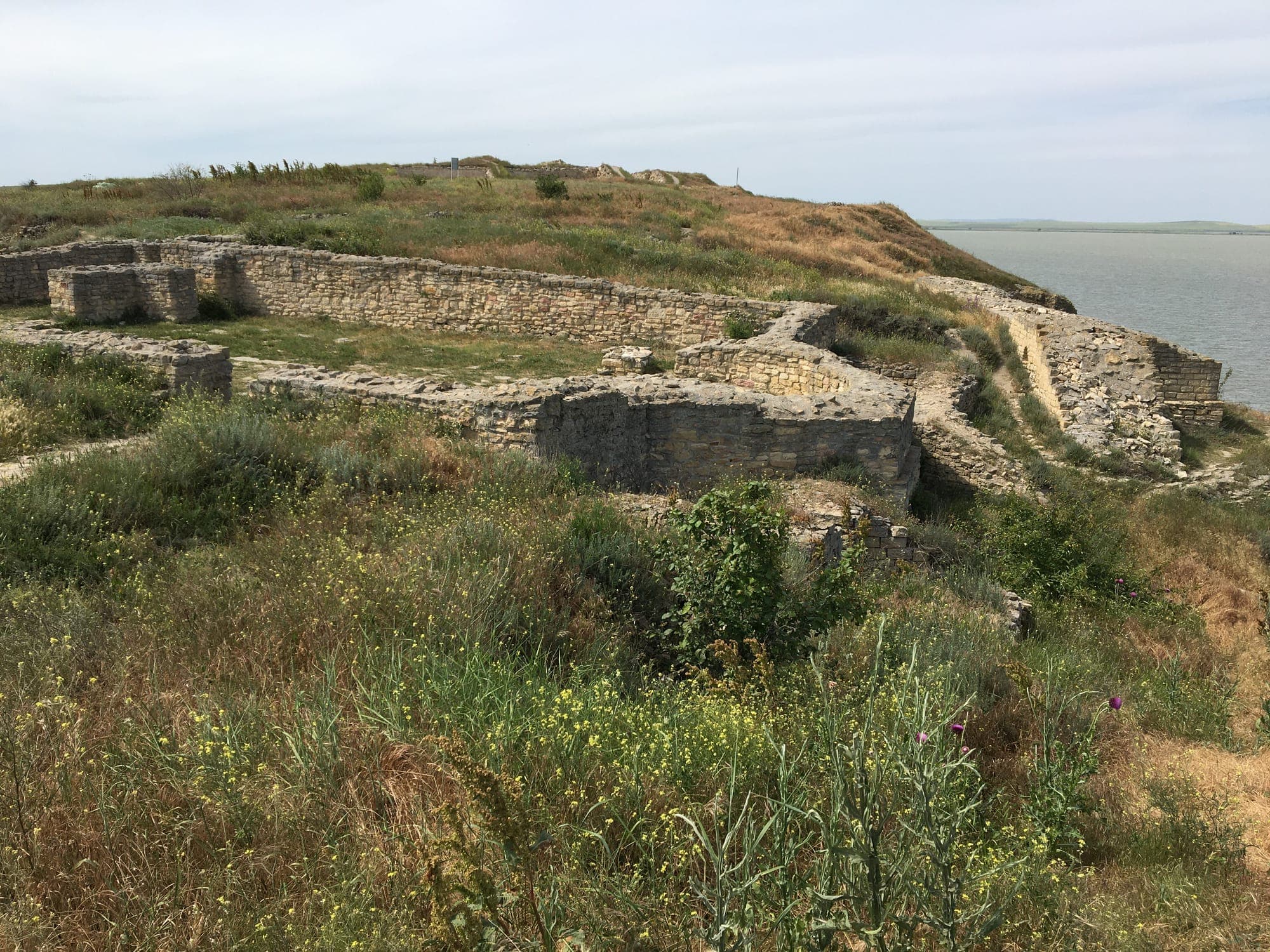
Fortresses near the Danube Delta: Enisala, Argamum, Halmyris and Histria
Around the southern lakes and on the Sfântu Gheorghe branch there are four fortresses with pages on the site, all tied to the time when Razim was a bay of the sea.
- Enisala Fortress, probably built by the Genoese in the 14th century on a limestone hill above lakes Razim and Babadag, ~40 km from Tulcea; from the walls you can see Razim to the horizon. Adult ticket 20 lei.
- Argamum Citadel, the Greek city of Orgame from the 7th century BC, on Cape Doloșman, ~7 km from Jurilovca, with four excavated early Christian basilicas. The site is in the open air.
- Halmyris Fortress, the Roman fort ~2.5 km east of Murighiol, by the Sfântu Gheorghe branch, where the crypt of the martyrs Epictetus and Astion was found in 2001. Adult ticket 12 lei.
- Histria Citadel, the colony founded by Miletus in the 7th century BC on the shore of Lake Sinoe, in Constanța County, with the site museum; it lies within the Danube Delta Biosphere Reserve. The citadel and the museum cost 16 lei each.
Prices are from the sights' pages, October 2026. Winter opening hours and the route from Tulcea are in the guide to things to see in Tulcea.


 Top 100
Tulcea Aquarium: the “Danube Delta” Ecotourism Museum Centre
Before or after the boat, you can also see the delta on dry land, at the Tulcea Aquarium, the everyday name of the “Danube Delta” Ecotourism Museum Centre (Centrul Muzeal Ecoturistic „Delta Dunării”), opened in 2009 next to the Tulcea riverfront. The aquarium has 24 fish species from the delta and the Black Sea, reef tanks and a tunnel that takes you among sturgeon, and the exhibition recreates in dioramas the habitats of the delta, the Razim–Sinoie lakes and the Măcin Mountains. It is open Tuesday–Sunday, 9:00–18:00, and the adult ticket is 30 lei (sight page, October 2026). The rest of the town is in the guide to things to see in Tulcea.

Things to do in the Danube Delta: sights and activities
The list of places to visit above translates into a few ways of spending time in the delta:
- A boat trip on the channels and lakes. The reserve has 15 approved water routes and 9 land routes, starting from Tulcea, Murighiol, Jurilovca and the delta villages. On the classic routes, Tulcea – the Mila 35 channel – Lake Furtuna – Mila 23 or Crișan – the Caraorman channel – lakes Puiu and Roșu, you pass through reeds, water lilies and willows. Durations, departures and prices are in the guide to trips in the delta.
- Birds. May–June, with the birds on their nests, is the best period; the species, the pelicans and the closed zones are in the guide to the delta's birds.
- A beach at the end of the branches, at Sulina, Sfântu Gheorghe and Gura Portiței.
- The forests on the ridges, Letea and Caraorman, on the approved routes.
- Fishing villages, such as Mila 23, and a fish meal in the village.
- Fortresses and museums on the shore of Razim and in Tulcea.
- Fishing, with a separate, free permit from ARBDD; the rules are in the fishing guide.
The Danube Delta, biosphere reserve and UNESCO site
The delta and the surrounding units were declared a biosphere reserve in 1990, under UNESCO's "Man and the Biosphere" programme; in September 1991 the reserve was recognised as a wetland of international importance (Ramsar), and in December 1991 it entered the World Heritage List, with 340,000 ha. Since 1999 it has formed, together with the Danube Biosphere Reserve in Ukraine, a transboundary biosphere reserve, and since 2000 it has held the European Diploma of Protected Areas.
The reserve is divided into three kinds of zone: 20 strictly protected zones, over 50,904 ha, closed to tourists; buffer zones, over 222,996 ha; and sustainable development zones, over 306,100 ha, where the villages, fishing and tourism are. For any visit you need the ARBDD access permit, 5 lei a day, 15 lei for 7 days or 30 lei until the end of the year; how to get it and who does not pay are in the guide to a first visit to the Danube Delta.
Is the Danube Delta the largest delta in Europe?
In the description on the World Heritage List, reproduced by Romania's National Heritage Institute, the delta the Danube forms where it flows into the Black Sea is called the largest and best preserved of Europe's deltas. For "the largest delta in the world" there is no official source that puts it in first place, so the superlative that can be supported is the European one.
Other figures searched for as superlatives: the reserve covers about 580,000 ha, has 365 recorded bird species and about 70% of its vegetation is dominated by reed (ARBDD). Lake Razim, on the edge of the delta, is Romania's largest lake, at about 415 km².
Deltas in Romania: how many there are and which you can visit
The Danube Delta is the delta where the river meets the sea. Besides it, three inland wetlands in Romania are called "deltas", all with pages on the site and in the Deltas category:
- Văcărești Nature Park (the Văcărești Delta), in southern Bucharest: 183 ha of pools and reeds in a former reservoir, with more than 180 bird species. Anyone searching for the "Bucharest delta" is looking for this park.
- Neajlov Delta, in Comana Nature Park in Giurgiu County, less than an hour from Bucharest: the Neajlov marsh, with channels and reed beds, seen by riverboat, boat or kayak.
- Balta Mică a Brăilei, the last free floodplain of the Danube between Giurgeni and Brăila, with river islands and lakes, which can be visited only by boat.
None of them is a delta on the sea, and none compares in size with the Danube Delta. How to visit each one is in the guide to the deltas near Bucharest.
 Top 100


What is not the Danube Delta: the Gorges, the Galați promenade, Lacu Sărat, Comana
A few places show up in searches next to "Danube Delta" without being in the delta:
- Danube Gorges (Cazanele Dunării) are the narrowest stretch of the Danube Gorge, between Dubova and Ogradena, in Mehedinți County, in the south-west of the country, with Serbia on the opposite bank, not where the river meets the sea.
- Danube Promenade (Faleza Dunării) in Galați is the town's riverside promenade, outside the delta.
- Lacu Sărat Resort, 5 km from Brăila, is a spa resort on the shore of a salt lake, not part of the delta.
- Comana Monastery, founded by Vlad the Impaler, is next to the lake in Comana Nature Park; the "delta" there is the Neajlov Delta.
- The "Bucharest delta" is Văcărești Nature Park (the Văcărești Delta), not the Danube Delta.
 Top 100


Before you go to the Danube Delta
- The ARBDD access permit is compulsory for everyone entering the reserve, including those who do not pay: 5 lei a day, 15 lei for 7 days, 30 lei until the end of the year (permise.ddbra.ro, October 2026). The details are in the guide to a first visit.
- Getting there: the car stays in Tulcea or in a village on the shore; Sulina, Sfântu Gheorghe, Mila 23, Crișan and Caraorman have no road. Chilia Veche is the only village in the delta with a road. Departures and ships are in the trips guide.
- Season: May–June, with high water and birds on their nests, before the heat and the mosquitoes of July–August; autumn is quiet. In 2026, check the state of the water first, in the section above.
- Closed zones: the 20 strictly protected zones, among them Roșca–Buhaiova and Sacalin–Zătoane, cannot be visited.
- In the villages: mobile signal is weak on the channels, most villages have no cash machine, and there is a pharmacy and a hospital only in Tulcea and Sulina; bring cash.
Frequently asked questions
- What is the Danube Delta?
- The Danube Delta is where the Danube splits into three branches, the Chilia, the Sulina and the Sfântu Gheorghe, and flows into the Black Sea. It is Romania's youngest region and a biosphere reserve of about 580,000 ha, on the UNESCO World Heritage List since 1991.
- Where is the Danube Delta on the map of Romania?
- In eastern Romania, in northern Dobruja, between the town of Tulcea and the Black Sea, next to Ukraine. The beach at Sulina is the easternmost inhabited place in the country.
- Which county is the Danube Delta in?
- Mainly Tulcea County: 87.73% of the reserve is in Tulcea, 12.23% in Constanța and 0.14% in Galați, according to ARBDD.
- How big is the Danube Delta?
- The Danube Delta Biosphere Reserve covers about 580,000 ha, roughly 5,800 km². Of this, 340,000 ha are on the UNESCO World Heritage List and 50,904 ha are strictly protected zones.
- Since when has the Danube Delta been a UNESCO site?
- Since December 1991. Also in 1991, in September, it was recognised as a wetland of international importance (Ramsar), and it has been a biosphere reserve since 1990.
- Is the Danube Delta the largest delta in Europe?
- Its description on the World Heritage List calls it the largest and best preserved of Europe's deltas. No official source ranks it first in the world.
- What to see in the Danube Delta?
- Mila 23 village, the Letea and Caraorman forests, the beaches at Sulina, Sfântu Gheorghe and Gura Portiței, the Old Lighthouse of Sulina, Lake Razim with the Enisala and Argamum fortresses, Halmyris Fortress and, in Tulcea, the “Danube Delta” Ecotourism Museum Centre.
- Did the Danube Delta dry up in 2026?
- It did not dry up, but the water fell sharply in summer 2026 and some channels became impassable for boats. On 30 October 2026 the Danube stood at 13 cm on the Tulcea gauge (AFDJ).
- How many deltas are there in Romania?
- The delta where a river meets the sea is the Danube Delta. Three inland wetlands are also called “deltas”: the Văcărești Delta in Bucharest, the Neajlov Delta at Comana and Balta Mică a Brăilei.
- Are the Danube Gorges (Cazanele Dunării) in the Danube Delta?
- No. The Cazanele Dunării are in the Danube Gorge, between Dubova and Ogradena, in Mehedinți County, in the south-west of the country, with Serbia on the opposite bank.
Sources
- ARBDD: about the Danube Delta Biosphere Reserve (area, counties, recognition)
- ARBDD: international recognition of the reserve
- ARBDD: functional zoning (strictly protected, buffer and economic zones)
- ARBDD: flora, fauna and ecosystems of the reserve
- ARBDD: access permits
- Navrom Delta: routes covered
- AFDJ: Danube water levels (30 October 2026)
- National Heritage Institute: the Danube Delta, World Heritage
- Agerpres, 5 August 2026: the delta authority approved the dredging of two channels in the reserve
- ARBDD: Decision 139 of 26 May 2026 banning vehicles in the Caraorman and Letea forests (PDF)
All guides
- Ski slopes in Romania: the ski resorts and ski areas by region, with a map
- When the ski slopes open and where the snow comes first: the ski season in Romania
- Sledging, alpine coasters and tubing in Romania: where to go with a sledge
- The longest ski slope in Romania and the other records: the largest ski area, the highest, the hardest
- The nearest ski slopes to Bucharest, Cluj, Brașov, Sibiu, Iași, Timișoara and Oradea: distances for a day of skiing
- Beginner and kids' ski slopes in Romania: where to learn to ski, ski schools and slope colours
- Caves in Romania: the ones you can visit, by area, with a map
- Ice caves and underground glaciers in Romania: Scărișoara, Focul Viu, Vârtop, Borsec
- Apuseni caves: a 2–3 day route through Bihor and Alba
- The largest cave in Romania and the other records: the longest, the deepest, the oldest show cave
- The nearest cave to Bucharest, Brașov, Cluj, Sibiu, Oradea and Timișoara: distances for a day trip
- Famous caves in Romania you cannot visit: Movile, Topolnița, Vântului, Coliboaia, Peștera cu Oase (and what to see instead)
- Stalactites and stalagmites: what they are, how a cave forms and where to see them in Romania
- Danube Delta trip: one, two or three days, where to start and how to get to Sulina and Sfântu Gheorghe
- Things to do in Tulcea: what to see in the city and around it
- Birds and wildlife of the Danube Delta: pelicans, where and when to see them
- Visiting the Danube Delta for the first time: the access permit, mosquitoes and when to go
- Fishing in the Danube Delta: the fishing permit, the 2026 closed season and where you may fish
- Sulina or Sfântu Gheorghe? The beaches of the Danube Delta (and Gura Portiței)
- Deltas near Bucharest: Văcărești, Comana (the Neajlov Delta) and Balta Mică a Brăilei
- The Romanian Black Sea coast: the resorts in order, north to south, with a map
- The best beaches in Romania (and the Blue Flag ones)
- The Black Sea season in Romania: when it opens, how long it lasts and when the water is warmest
- Wild beaches on the Romanian coast: Corbu, Vadu, Tuzla and the south
- Which Romanian seaside resort to choose: for young people, families, quiet, budget
- The Romanian seaside with kids: resorts, shallow beaches and what to do off the beach
- Things to do in Constanța: what to see in the city, on the seafront and nearby
- Jellyfish, sharks and lifeguard flags in the Black Sea
- Salt mines in Romania: the complete guide to the salt mines you can visit
- The largest, the deepest and the oldest salt mine in Romania
- The nearest salt mine to Bucharest, Cluj, Brașov, Sibiu, Iași, Timișoara, Oradea, Constanța and other cities
- Salt mines with children and babies: from what age, which one suits, what to bring
- Turda or Slănic Prahova? Which salt mine to choose
- Visiting a salt mine for the first time: temperature, clothing, how long, lift or bus, dogs
- Salt lakes and salt baths in Romania: where to swim, season and prices
- Salt mine therapy in Romania: what the operators say, how long to stay, which mines have a treatment base